Every successful renovation begins with accurate knowledge of the existing building. Whether you're converting a Victorian warehouse, extending a family home, or restoring a heritage property, architects need precise dimensional data to create effective designs. Topo Surveyor provides measured building surveys that capture every detail of existing structures, giving architects the CAD drawings they need to transform buildings while respecting their character and constraints.
This guide explains how measured building surveys work, why they're essential for renovations, and how professional survey data enables successful building projects from concept through to completion.
What Measured Building Surveys Capture
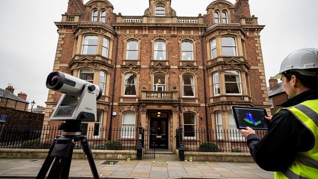
A measured building survey documents existing buildings in comprehensive detail. Unlike simple floor plan sketches, professional surveys provide accurate measurements of every architectural element affecting design decisions. Our land surveyor team uses highly specialised survey equipment including 3D laser scanners and total station instruments to capture millions of measurement points, creating CAD drawings showing buildings exactly as they exist.
Floor plans represent the foundation of measured surveys. These drawings show room layouts, wall positions, door and window locations, structural elements like columns and beams, fixed features including staircases and built-in furniture, and floor level changes throughout the building. Plans are produced at appropriate scales—typically 1:50 for detailed architectural work or 1:100 for larger buildings—showing dimensions accurate to millimeters. Architects use these floor plans as the base for designing alterations, extensions, and space reconfigurations.
Elevation drawings document external and internal wall surfaces. External elevations show facade treatments, window and door patterns, architectural features and decorative elements, roof lines and chimneys, and adjacent building relationships. Internal elevations capture room character through details like ceiling heights, moldings and cornices, fireplace designs, fitted joinery, and surface finishes. This level of detail helps architects design interventions that respect existing character while achieving functional improvements.
Section drawings reveal the vertical organization of buildings—floor-to-ceiling heights, roof constructions and void spaces, staircase arrangements, structural systems, and ceiling types including exposed beams or coffered designs. Sections prove particularly valuable for listed buildings or heritage properties where understanding historic construction methods informs sensitive renovation approaches. The survey data shows what exists, helping architects propose changes that work with rather than against the building's nature.
Roof plans capture complexities that often surprise renovation planners. The measured survey maps roof slopes and valleys, gutter and downpipe arrangements, skylights and roof lights, chimneys and ventilation terminals, and parapets and edge details. This information proves critical when planning roof modifications, solar panel installations, or additional floor levels within roof spaces. Knowing exactly what exists prevents design assumptions that prove wrong during construction.
Reflective ceiling plans document ceiling features in heritage buildings or commercial spaces. These specialized drawings show decorative plasterwork, lighting fixtures and positions, air conditioning and ventilation outlets, structural elements visible above, and access hatches and service points. For buildings with significant ceiling character, understanding these features influences design decisions about lighting, services routing, and conservation requirements.
Technology Transforming Building Surveys
Modern measured building survey technology has revolutionized how surveyors capture and present building data. Traditional measuring tapes and hand-drawn surveys have given way to sophisticated equipment delivering unprecedented accuracy and detail.
3D laser scanning represents the cutting edge of measured survey technology. Scanners emit millions of laser pulses per second, measuring distances to surfaces and creating detailed point clouds representing entire buildings. A typical survey session might capture 50-100 million measurement points, documenting every visible surface feature. This comprehensive data capture means that even details not immediately relevant to current projects are recorded, available for future reference if design changes occur or additional information becomes needed.
Laser scanning excels for complex buildings where traditional surveying would be time-consuming and expensive. The technology captures intricate architectural details, irregular geometries, and ornate features with equal ease. Heritage buildings benefit particularly from laser scanning—Victorian factories with exposed brick and ironwork, Georgian townhouses with elaborate cornices and moldings, medieval structures with irregular walls and floors all survey efficiently with laser scanners. The resulting point cloud data provides an archival record preserving building geometry as it exists at survey time.
Total station instruments complement laser scanning for dimensional control and accuracy verification. These precision theodolites measure angles and distances with millimeter accuracy, establishing control networks that ensure all survey data references consistently. Our land surveyor team uses total stations to measure key dimensions, verify scanner data accuracy, and establish coordinate frameworks relating building surveys to external topographical surveys or national coordinate systems.
Photogrammetry processes multiple photographs to create three-dimensional models. This technique works well for facades, architectural details, and areas difficult to access with scanners. The photographs themselves provide useful documentation of materials, colors, and textures that supplement geometric survey data. Architects appreciate photogrammetry results for their visual clarity alongside dimensional accuracy.
Traditional survey methods still have roles in measured building surveys. Hand measurements verify dimensions in critical areas, tape measures capture details in spaces too confined for equipment, and hand-drawn sketches record observations about construction methods, material conditions, and features worth documenting beyond pure geometry. Our surveyors combine technology with traditional skills to deliver comprehensive building intelligence.
Survey Accuracy and Detail Levels
Measured building surveys can be specified at different accuracy and detail levels depending on project requirements and budgets. Understanding these levels helps commission appropriate surveys.
RICS guidance defines four common survey accuracy levels from high-level reconnaissance surveys through to detailed heritage documentation. Most renovation projects require Measured Survey Accuracy level, typically achieving plus-or-minus 5-15mm accuracy for overall dimensions and capturing architectural details affecting design. This accuracy suffices for most architectural design, building regulation applications, and construction planning. Heritage conservation or specialist engineering might demand higher accuracy with plus-or-minus 2-5mm tolerances and comprehensive detail capture including decorative elements, construction methods, and material characteristics.
Detail level specifications affect what features surveys capture and how drawings represent them. Basic surveys show structural elements, openings, and major features. Standard surveys add architectural details, finishes, and services. Detailed surveys capture decorative elements, construction details, and condition observations. The appropriate detail level depends on renovation scope—converting an industrial unit to residential might need basic surveys focusing on space and structure, while restoring a listed building demands detailed surveys documenting character-defining features.
Survey deliverables vary with project needs. All measured surveys provide CAD drawings in formats like DWG and PDF suitable for architect use. Some projects benefit from 3D building models enabling virtual walkthroughs and coordination with Building Information Modeling workflows. Point cloud data from laser scanning can be delivered allowing detailed interrogation beyond what CAD drawings show. Photographic documentation supplements geometric data with visual records of existing conditions.
Why Renovations Need Measured Surveys
Attempting renovations without accurate building surveys creates risks and costs that far exceed survey expenses. Professional measured surveys provide the foundation for successful projects in multiple ways.
Design accuracy depends fundamentally on understanding existing conditions. Architects designing extensions must know exact building dimensions, floor levels, and wall positions to create proposals that actually fit. Interior reconfigurations require accurate room sizes to assess whether new layouts achieve space requirements. Service upgrades need knowledge of existing structural elements that might conflict with new installations. Without measured survey data, designs risk being wrong from the outset, requiring expensive revisions when construction reveals dimensional errors.
Building regulation compliance requires accurate documentation of existing buildings. Regulations around means of escape, structural adequacy, and energy performance all reference existing building geometry. Submitting applications with inaccurate drawings invites rejection or requests for clarification causing delays. Measured surveys provide the accurate base data that building control officers need to assess proposals against regulations.
Listed building consent and conservation area approval processes scrutinize proposals carefully against existing building character. Planning officers and heritage consultants need to see exactly how interventions relate to existing features. Measured surveys capturing architectural details demonstrate that proposals have been designed with proper understanding of the building's character. This attention to existing conditions strengthens applications and demonstrates respect for heritage significance.
Construction efficiency improves dramatically when contractors have accurate building information. Builders can order materials confidently knowing dimensions are reliable. Prefabricated elements like windows or steelwork can be manufactured to exact sizes without contingency allowances. Services engineers can route pipes and cables knowing where structure and spaces actually exist rather than discovering constraints during installation. This certainty reduces construction costs and timescales by eliminating guesswork and enabling proper planning.
Project risk reduces when everyone works from accurate information. Contractors price work more competitively when they understand scope clearly without uncertainty premiums for unknown conditions. Clients avoid budget overruns from design changes addressing dimensional errors discovered during construction. Projects complete on time without delays resolving conflicts between assumed and actual conditions. The peace of mind from knowing projects start with sound information is valuable beyond financial calculation.
Heritage Buildings and Conservation Requirements
Listed buildings and heritage properties demand particular care in surveying and renovation. The special character that merits preservation must be understood thoroughly before proposing changes. Measured building surveys provide the foundation for sensitive conservation.
Heritage surveys capture not just geometry but character-defining features. Historic England and equivalent bodies across the UK emphasize significance when assessing proposals affecting heritage assets. The measured survey should document features contributing to significance—decorative plasterwork that demonstrates craftsmanship, structural systems revealing construction techniques, spatial arrangements reflecting historical use, and architectural details expressing period character. This documentation helps architects design interventions minimizing impact on significance while achieving necessary building improvements.
Conservation philosophy emphasizes minimum intervention and reversibility. Accurate surveys help identify where changes can occur with least heritage impact. Perhaps a less significant elevation can accommodate windows while principal facades remain untouched. Maybe modern services can route through later additions avoiding original fabric. Or structural improvements can use techniques respecting historic materials. These decisions require comprehensive knowledge of existing buildings that measured surveys provide.
Recording before alteration creates archival documentation preserving knowledge even when work affects historic fabric. If intervention proves necessary to sustain building use, detailed survey records ensure understanding of what existed survives. This "preservation by record" is accepted practice when physical preservation conflicts with building viability. Our measured building surveys provide this archival function, creating detailed records meeting Historic England guidance on building recording.
Survey Process and Property Access
Understanding the measured building survey process helps property owners prepare and ensures surveys proceed efficiently. The process typically follows clear stages from initial instruction through to drawing delivery.
Initial consultation clarifies project scope and survey requirements. We discuss renovation intentions, architect needs, detail level requirements, and deliverable formats. This consultation ensures commissioned surveys provide information actually needed without unnecessary expense on excessive detail or coverage.
Property access represents the critical requirement for surveys. Our surveyor will conduct site visits requiring access to all spaces being surveyed. For occupied properties, this means coordinating with residents or tenants. For commercial properties, scheduling around business operations. For vacant properties, ensuring keys and secure access. Survey duration depends on building size and detail required—a typical house might survey in 2-4 hours, while large commercial buildings need full days or multiple visits.
Survey fieldwork proceeds systematically to ensure comprehensive coverage. The surveyor works through the building methodically, setting up laser scanning stations or total station positions to capture data from all areas. Photographs document features and provide context. Hand measurements verify dimensions and capture details. Notes record observations about construction, condition, and features affecting renovation planning. Professional surveyors work efficiently to minimize disruption while ensuring thorough documentation.
Data processing transforms raw measurements into usable CAD drawings. Point cloud data from laser scanning is registered and cleaned, removing extraneous elements like furniture while retaining building fabric. Measurements are compiled into dimensioned drawings following CAD conventions. Plans, elevations, and sections are prepared at specified scales. The survey report is compiled documenting methodology, accuracy achieved, and limitations. Deliverables are packaged in agreed formats for architect use. This processing typically requires several days to a week depending on building complexity and detail level.
Working with Architects and Designers
Measured building surveys serve architects primarily, so understanding architect needs ensures surveys deliver maximum value. Our experience supporting architectural practices across the UK has taught us what makes survey data truly useful for design work.
CAD file organization affects usability significantly. We structure drawings with logical layer systems allowing architects to manipulate and build upon survey data easily. Separate layers for walls, openings, structural elements, architectural details, dimensions, and annotations let architects control visibility and extract information relevant to specific design tasks. Files are delivered in widely-used formats compatible with major CAD software packages.
Dimension presentation balances completeness with clarity. Over-dimensioned drawings become cluttered and confusing. Under-dimensioned drawings leave architects measuring and calculating. We provide comprehensive dimensioning of overall sizes, room dimensions, structural grids, and key features, while making underlying coordinates available for architects needing specific measurements.
Coordination with topographical surveys benefits projects involving both building alterations and external works. We ensure building surveys reference the same coordinate system as site topographical surveys, allowing seamless integration of buildings into site context. This coordination is essential for projects involving extensions, landscape works, or external services where building and site must be considered together.
Follow-up support helps architects use survey data effectively. Questions inevitably arise during design—clarifying ambiguous features, confirming dimensions, understanding construction details. We remain available to answer queries and can sometimes provide additional information from survey data without site revisits if properly questioned during original surveys.
Conclusion: Building on Solid Foundations
Successful renovations begin with accurate knowledge of existing buildings. Measured building surveys provide architects with reliable dimensional data, enabling design decisions based on reality rather than assumptions. Whether you're renovating a family home or transforming a heritage building, professional surveys deliver the accurate CAD drawings that projects need to succeed.
At Topo Surveyor, our measured building surveys combine advanced technology with experienced surveyors to capture building detail with precision. We understand what architects need and deliver survey data that supports effective design and smooth project delivery.
If you're planning building renovations or alterations, get in touch with our survey experts. We'll discuss your project, recommend appropriate survey scope, and provide professional measured building surveys giving your renovation the accurate foundation it deserves.
Professional Measured Building Surveys
Our experienced surveyors use 3D laser scanning and precision instruments to capture building detail accurately. We deliver comprehensive CAD drawings supporting architectural design and renovation planning.
Need Accurate Building Measurements?
Our measured building surveys provide architects with precise CAD drawings essential for successful renovation projects. We capture every detail of your building using advanced laser scanning technology.