Every year in the UK, thousands of underground utility strikes cause project delays, costly repairs, service disruptions, and tragically, injuries and deaths. These incidents are almost entirely preventable through professional underground utility surveys before excavation begins. Topo Surveyor has mapped underground services for countless construction projects, and we've seen firsthand how accurate utility surveys protect workers, save money, and keep projects on schedule.
This comprehensive guide explains why underground utility surveys matter so critically, what they involve, and how they deliver value far exceeding their cost. Whether you're planning a small garden dig or major construction project, understanding what lies beneath can mean the difference between smooth progress and catastrophic problems.
The Hidden Underground Infrastructure
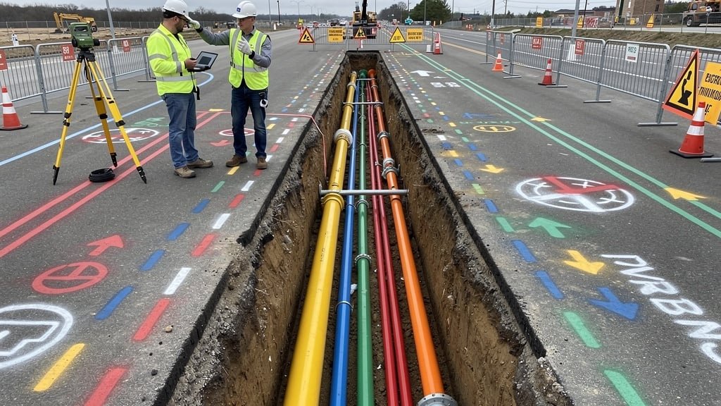
Beneath every UK street, garden, and development site lies a complex network of buried services that modern life depends upon. Water mains deliver fresh water to millions of properties. Gas pipelines distribute fuel for heating and cooking. Electricity cables power homes and businesses. Telecommunications and fiber optic networks enable connectivity. Drainage and sewer systems remove wastewater. These underground utilities represent billions of pounds of infrastructure investment, and they're remarkably easy to damage if you don't know where they run.
The challenge facing anyone planning excavation is that underground services are invisible. You might see manhole covers or meter boxes indicating services nearby, but these surface features don't reveal exact pipe positions, depths, or routes. Historical plans from utility companies show approximate locations based on installation records, but decades of ground movement, repairs, and additional services mean actual positions often differ from plans by several meters.
Utility companies maintain records of their networks, but these records have limitations. Different utilities use different coordinate systems and accuracy standards. Records might not show abandoned services no longer in use but still buried. Private services serving individual properties don't appear in utility company records at all. Multiple utilities might run in the same trench without any organization having complete knowledge of all services present. This fragmented information landscape makes professional underground utility surveys essential for anyone disturbing the ground.
The True Cost of Utility Strikes
When excavation equipment strikes buried utilities, consequences cascade rapidly and expensively. Understanding these costs illustrates why utility surveys deliver such compelling value.
Direct repair costs hit immediately. Damaged water mains flood excavations and surrounding areas, requiring emergency shutdowns, specialist repair crews, and water network restoration. Gas pipeline strikes demand immediate evacuation while emergency services secure the scene. Electricity cable damage requires specialist high-voltage repair teams working under strict safety procedures. Even straightforward repairs cost thousands of pounds, while complex situations involving multiple damaged services or difficult access can reach tens of thousands.
Project delays multiply costs substantially. When utilities are struck, work stops immediately. The site must be secured, emergency services notified, utility companies called out, and repairs completed before excavation can resume. This delay might last days or weeks depending on damage severity and repair complexity. Meanwhile, contractors, equipment, and workers sit idle generating costs without progress. Schedules slip, affecting subsequent work phases and potentially triggering contract penalties or late delivery charges.
Service disruption affects entire communities. A severed water main leaves homes and businesses without water for hours or days. Gas pipeline damage requires area evacuation and extended service suspension. Electricity cable strikes black out neighborhoods. Telecommunications breaks disrupt connectivity for residential and business customers. Utility companies face compensation claims from affected customers, and they pass these costs back to contractors responsible for strikes through substantial penalties often exceeding repair costs.
Safety incidents carry costs beyond measurement in pounds. Workers die every year from utility strikes—electrocutions from damaged cables, explosions from gas leaks, crushing injuries from collapsing excavations weakened by utility damage. Serious injuries cause lifelong impacts on workers and families. Health and Safety Executive investigations follow serious incidents, potentially leading to prosecutions, fines, and director disqualifications. Company reputations suffer lasting damage when safety failures become public knowledge.
Insurance implications extend long after incidents. Utility strike claims increase insurance premiums substantially. Repeated incidents might make insurance difficult or impossible to obtain. Companies without adequate insurance face bankruptcy-level liability exposure. Even single serious incidents generate legal costs defending against claims and regulatory action.
Contrast these costs with underground utility surveys. A comprehensive utility survey for a typical construction site costs £1,000-£3,000 depending on size and complexity. Compare this to average utility strike costs of £10,000-£50,000 for moderate incidents and potentially millions for serious strikes causing injuries or major infrastructure damage. The return on investment for utility surveys is compelling—spending thousands to avoid tens or hundreds of thousands in potential costs represents sound risk management.
How Underground Utility Surveys Work
Professional utility surveys use multiple detection technologies to locate buried services accurately. Our land surveyor team applies various techniques depending on utility types, ground conditions, and site circumstances.
Electromagnetic locators detect buried metal pipes and cables by generating electromagnetic fields and identifying distortions caused by conductive materials. These devices excel at locating metallic water pipes, gas pipes, and electricity cables. The surveyor walks the site methodically, marking detected services with spray paint or pins. Depth measurements help determine how deeply utilities are buried, though accuracy varies with soil conditions and utility materials.
Ground-penetrating radar uses radio waves reflected by buried objects to create subsurface images. GPR detects both metallic and non-metallic utilities including plastic pipes, concrete pipes, and fiber optic cables that electromagnetic locators miss. The technology provides detailed images showing utility depths, sizes, and positions. GPR works best in dry conditions—waterlogged ground reduces penetration depth and image quality. Our surveyors assess site conditions and select appropriate survey techniques accordingly.
Acoustic detection locates pressurized pipes by identifying sounds from flowing water or gas. This technique helps trace active water mains and gas pipes even when other methods struggle. Acoustic methods work particularly well for plastic water pipes that don't respond to electromagnetic detection.
Signal tracing applies electrical signals directly to utilities through access points, then traces the signal along the utility route. This technique provides highly accurate location for the specific utility traced and helps distinguish target utilities from other nearby services. Signal tracing requires access to the utility—connection points, valves, or meters—and works best for continuous metallic services.
Vacuum excavation confirms utility positions by carefully exposing suspected services in small trial holes. This invasive verification technique provides definitive proof of utility presence, depth, and characteristics. We use vacuum excavation sparingly, focusing on areas where clarification is critical or non-invasive methods provide ambiguous results.
Our underground utility surveys combine multiple techniques to achieve comprehensive detection. We start with desktop research examining utility company plans, historical maps, and previous surveys. This background information guides fieldwork by identifying areas requiring careful attention. During site surveys, we systematically cover the entire investigation area using appropriate detection methods, marking all discovered utilities clearly. Survey data is processed into CAD drawings showing utility positions, depths, and characteristics overlaid on topographical surveys for complete site intelligence.
Understanding Survey Limitations
Professional utility surveys dramatically reduce strike risk, but they're not infallible. Understanding survey limitations helps set appropriate expectations and guide safe excavation practices.
Detection depth limits affect all survey techniques. Electromagnetic locators typically detect utilities to 3-4 meters depth in good conditions. Ground-penetrating radar penetrates 2-3 meters in dry ground, less in wet or clay soils. Very deep utilities below these thresholds might not be detected. Our survey reports clearly state maximum investigation depths achieved.
Small or deeply buried services sometimes escape detection. A thin garden hose buried shallowly might not generate sufficient electromagnetic response to trigger locators. Fiber optic cables laid directly in ground without protective ducting can be difficult to detect with any method. We document survey methodologies and limitations so clients understand what has and hasn't been detected.
Abandoned utilities complicate interpretation. Disused pipes and cables remain buried indefinitely, and they respond to detection equipment identically to active services. Without excavation verification, distinguishing abandoned from active utilities is often impossible. We map all detected linear features and note where records indicate abandonment, but assume all detected utilities pose risk until proven otherwise.
Ground conditions affect detection capability. Dense clay, waterlogged soils, heavily reinforced concrete, and metal debris all interfere with detection equipment. We assess ground conditions during surveys and adjust techniques accordingly, but challenging conditions reduce detection confidence.
These limitations don't diminish utility survey value—they simply require safe excavation practices even after surveys are completed. Survey reports show where utilities are positively identified, and they indicate areas where detection confidence is lower due to conditions or depth limitations. Excavation teams use this information to plan safe digging strategies respecting known utilities and remaining vigilant for unexpected discoveries.
Integrating Utility Surveys with Construction Projects
Underground utility surveys deliver maximum value when integrated properly into construction planning and execution. The survey report represents the starting point for utility-aware project management, not the end of utility consideration.
Project planning uses utility survey data to inform design decisions. Architects and engineers review utility positions when designing foundations, drainage systems, and services routes. Sometimes designs must be adjusted to avoid clashes with existing utilities or costly utility diversions. Getting correct information early through utility surveys allows these design adjustments before construction begins, when changes cost relatively little compared to modifications during construction.
Health and safety planning incorporates utility survey findings into method statements and risk assessments. Contractors identify work areas with utility proximity, specify precautionary measures for excavation near services, establish emergency procedures for utility strikes, and brief workers on utility locations and protocols. The utility survey provides factual basis for these safety measures.
Excavation procedures adapt based on utility survey data. In areas clear of utilities, excavation can proceed at normal speed using appropriate equipment. Near detected utilities, digging slows and becomes more careful, potentially switching to hand digging in immediate proximity to services. Some projects use permanent markings showing utility positions so operators have constant visual reference during earthworks.
Utility protection measures prevent damage during construction. Where new works pass near existing utilities, protective measures might include padding pipes, bridging across excavations, supporting cables, or installing barriers preventing equipment approach. Our survey reports help contractors identify where protection is necessary and inform protection design.
Statutory utility searches complement underground utility surveys. By law, contractors must notify utility companies before excavation. Companies provide plans showing their services and sometimes offer site visits marking their networks. This statutory information combined with professional surveys provides comprehensive intelligence about underground risks.
Different Projects, Different Requirements
Underground utility survey requirements vary with project type, size, and risk profile. Understanding what your specific project needs ensures appropriate survey scope.
For residential extensions and renovations, utility surveys focus on the immediate construction footprint plus surrounding margins. The survey identifies services that might be affected by foundations, drainage works, or access routes. Even small projects benefit from utility surveys—striking a buried cable while digging foundations creates the same problems whether the project is large or small.
New build housing developments require comprehensive utility surveys covering entire sites plus access roads and utility corridors. The survey informs site layout planning, identifies constraints on building positions, and reveals where utility connections are feasible. Developers use utility survey data during land due diligence to understand connection costs and potential obstacles.
Infrastructure projects like roads, railways, and utilities installation demand the most extensive utility survey coverage. These linear projects cross varied ground potentially encountering numerous existing utilities. Survey accuracy and detail requirements increase given the project scale and consequences of utility strikes affecting major infrastructure.
Commercial and industrial developments need utility surveys appropriate to proposed operations. Heavy foundations for large buildings, extensive drainage systems, utility connections for high-demand occupancies, and landscaping works all require utility intelligence. Survey scope reflects the complexity of ground works and service provision.
When you get in touch with Topo Surveyor about utility surveys, we discuss your project type, ground works extent, and particular concerns. This consultation helps us recommend survey scope appropriate to your needs and risks, providing necessary information without commissioning unnecessarily extensive surveys where simpler approaches suffice.
Regulatory and Legal Requirements
Several regulations and legal requirements affect underground utility surveys and excavation practices in the UK. Understanding these obligations helps ensure compliance and demonstrates due diligence.
The Health and Safety at Work Act places general duties on employers to ensure worker safety. Excavating without knowing utility locations fails to satisfy these duties. When utility strikes cause injuries, Health and Safety Executive investigations examine what steps contractors took to identify underground risks. Professional utility surveys provide evidence of reasonable precautions.
Construction Design and Management Regulations require hazard identification during project planning. Underground utilities represent hazards that must be assessed and controlled. Principal designers and contractors must demonstrate they've investigated utility risks—utility surveys provide this evidence.
The New Roads and Street Works Act governs excavation in public highways. Anyone digging in roads must notify utilities and obtain location information. While utility companies provide plans, professional surveys supplement this information with verified on-site detection.
Utility companies include conditions in their plans requiring contractors to verify positions before excavation. Simply relying on provided plans without verification doesn't satisfy these conditions. If contractors damage utilities without conducting verification surveys, they struggle to claim the strike was unavoidable or that utility plans were inaccurate.
Civil liability for utility damage rests with contractors who cause strikes. Even if utilities are positioned incorrectly or plans are inaccurate, contractors who excavate without appropriate investigation face liability for resulting damage. Professional utility surveys help demonstrate that contractors took reasonable steps to identify utilities before digging.
Choosing Professional Utility Survey Providers
Not all utility survey providers deliver equal quality or thoroughness. Selecting experienced survey companies affects project outcomes significantly.
Equipment capability matters. Providers should use modern electromagnetic locators, ground-penetrating radar, and supplementary detection methods. Multiple technologies increase detection success across different utility types and ground conditions. We invest continuously in the latest highly specialised survey equipment to maintain detection effectiveness.
Surveyor experience affects result quality substantially. Utility survey interpretation requires skill—distinguishing utilities from other buried objects, identifying signal interference, assessing ground condition impacts on detection. Our land surveyor team brings years of utility survey experience to every project, applying professional judgment to deliver reliable results.
Survey reporting clarity determines utility data usefulness. Reports must present findings clearly with comprehensive CAD drawings showing detected utilities overlaid on site plans, photographs documenting field conditions, narrative descriptions explaining methodologies and findings, and limitation statements defining survey scope and confidence levels. We provide detailed survey reports that contractors and designers can use confidently.
Professional accreditation demonstrates competence and accountability. Our topographical surveyors maintain professional memberships with bodies like RICS and industry utility associations. These affiliations require continuing professional development and adherence to standards, providing clients with confidence in service quality.
Conclusion: Prevention Over Cure
Underground utility strikes are costly, dangerous, and almost entirely preventable through professional utility surveys before excavation begins. Whether you're planning a small garden project or major development, knowing what's buried beneath your site protects workers, saves money, prevents disruption, and demonstrates professional diligence.
At Topo Surveyor, we provide comprehensive underground utility surveys using advanced detection technology and experienced survey professionals. Our approach combines multiple survey techniques, thorough site investigation, and clear reporting to give you confidence about underground conditions before breaking ground.
If you're planning any project involving excavation, get in touch with our survey experts. We'll discuss your project requirements, explain utility survey processes, and provide professional land surveying services that protect your project from underground surprises.
Professional Utility Survey Services
Our experienced surveyors use electromagnetic detection, ground-penetrating radar, and advanced techniques to map underground services accurately before excavation. Protect your project with professional utility surveys.
Protect Your Project with Utility Surveys
Avoid costly damage, delays, and safety hazards with comprehensive underground utility surveys. Our team uses advanced detection equipment to accurately map all buried services before excavation begins.